
On this page you can see an online map of earthquakes in the world, a graph and detailed statistics of aftershocks (today 23 August 2023). The strength of an earthquake depends on the depth of the shock, the distance to the epicenter, and is measured in points on the Richter scale, characterizing the magnitude (the energy released in the form of seismic waves).
In this block, earthquakes are marked in Moscow (Russia) or those closest to Moscow, if the region is not seismically active; How many earthquakes were there today, in a year, or in a selected period; also, the number of aftershocks with a magnitude above 5 and the strongest earthquake in 2023.
We collect information from all available sources, including: BGS (British Geological Survey), EMSC (European Mediterranean Seismological Centre), GA (Australian Center for Geosciences), GDACS (Global Disaster Coordination and Alert System) , GFZ (German Research Center for Geosciences), GHNZ (Geological Hazard Information Center of New Zealand), NRCAN (Natural Resources Research Center of Canada), TMD (Thai Meteorological Department), USGS (USGS), UOA (Athens Seismological Laboratory) . In the settings, you can select any set of seismic monitoring services to display earthquakes on the map. The data is updated in real time, at short intervals.
In this block, earthquakes are marked in Gvardeisky (Russia) or those closest to Gvardeisky, if the region is not seismically active; How many earthquakes were there today, in a year, or in a selected period; also, the number of aftershocks with a magnitude above 5 and the strongest earthquake in 2023.
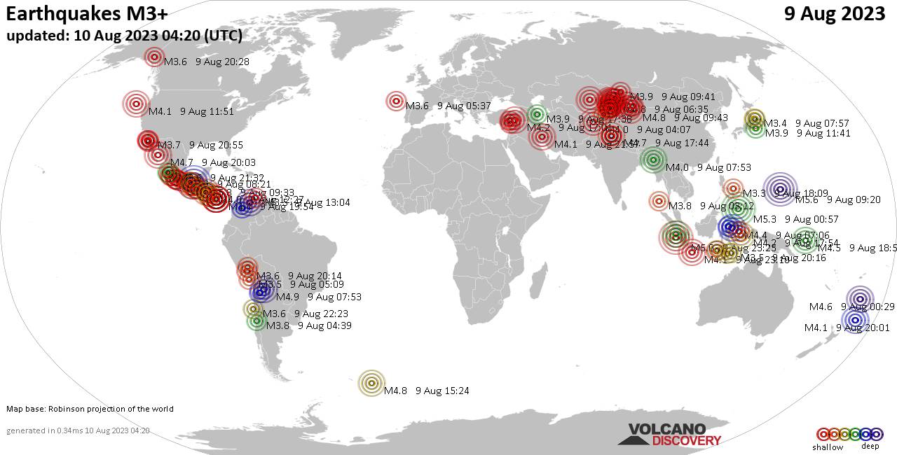
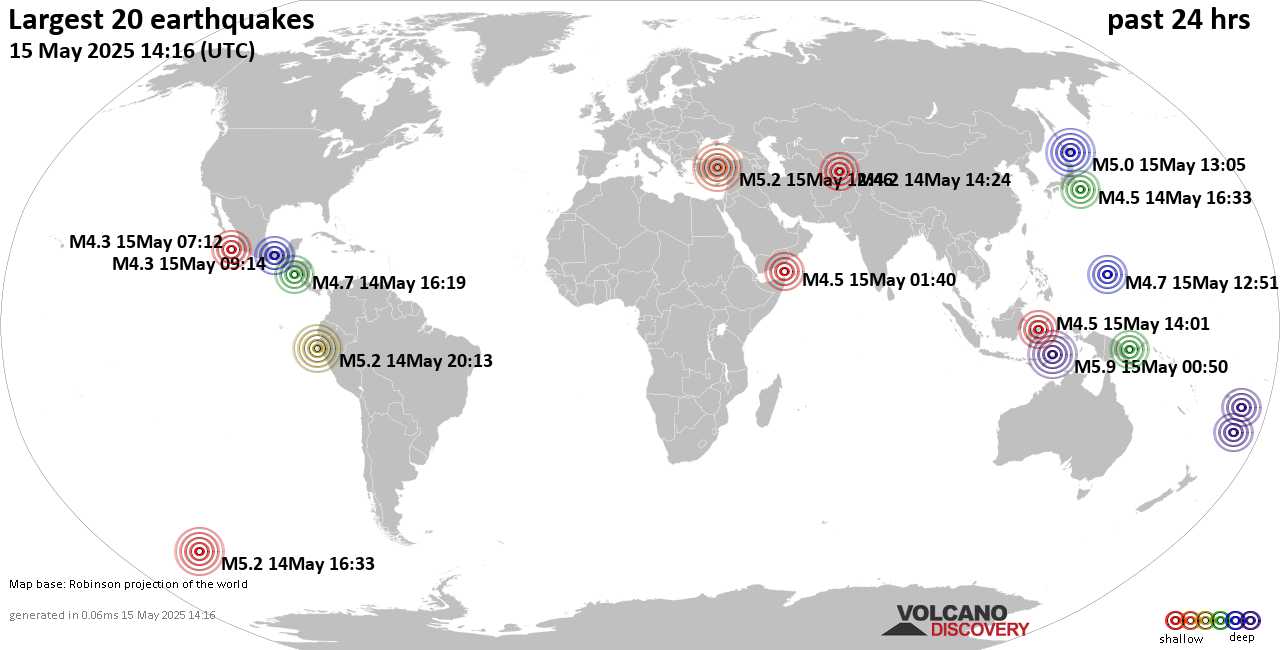
World map showing earthquakes greater than 3 on August 9, 2023
Summary: land. Mag.5+, earth. Mag.4+, earth. Mag.3+, earth. Mag.2+ (total 398)
Magnitude 5+: ground Magnitude 4+: ground Magnitude 3+: ground Magnitude 2+: ground No earthquakes of magnitude greater than 6 or greater
Estimated total seismic energy: 6.7 x 10¹³ J (18.7 gigawatt-hours, equivalent to 16099 tons of TNT or 1 atomic bomb!) learn more
- Top 10 Earthquakes in the World (Aug 9, 2023)
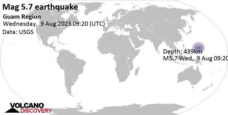
- Mag 5. 6 Philippine Sea, 80 km west of Dededo Village, Guam
- Mag 5. 3 Philippine Sea, 56 km south of Mati, Philippines
- Mag 5. 0 Indian Ocean, 123 km west of Bengkulu, Indonesia
- Mag 4. 9 Tarija, 37 km west of Villazón, Bolivia
- Mag 4. 8 South Atlantic Ocean, South Georgia and the South Sandwich Islands
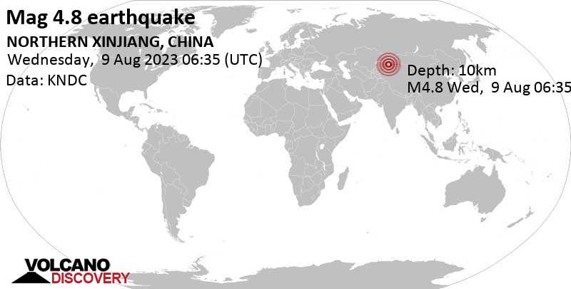
- Mag 4. 8,146 km south of Turpan, Xinjiang, China
- Mag 4. 8 24 km southeast of Bole, China
- Mag 4. 7 87 km west of Higuera de Zaragoza, Ahome, Sinaloa, Mexico
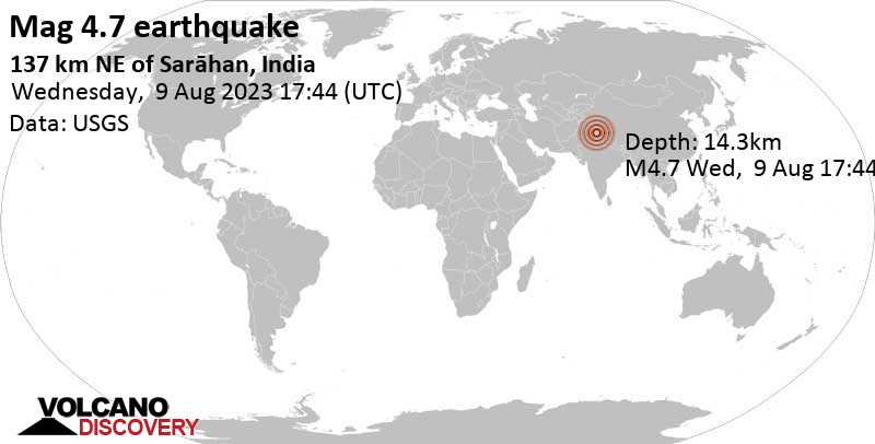
- Mag 4. 7 Tibet, China, 214 km northeast of Shimla, India
- Earthquakes reported
- Mag 3. 8 36 km southeast of Valparaiso, Provincia de Valparaiso, Region de Valparaiso, Chile — 14 reports
- Mag 4. 7 Tibet, China, 214 km northeast of Shimla, India — 13 reports
- Mag 3. 1 21 km northeast of San José, Costa Rica — 9 reports
- Mag 3. 5 Caribbean, 23 km northwest of Puerto Cabello, Venezuela — 9 reports
- Mag 3. 6 20 km northeast of San José, Costa Rica — 7 reports
- Mag 3. 1 31 km к западу от Сантьяго, Provincia de Santiago, Столичная область, Чили — 7 отчетов
- Mag 3. 2 40 km к юго-западу от Хило, Гавайи County, Соединенные Штаты — 5 отчетов
- Mag 4. 4 21 km к северо-востоку от Сан-Хосе, Коста-Рика — 4 отчета
- Mag 2. 7 21 km к юго-востоку от Пейн, Provincia de Maipo, Столичная область, Чили — 3 отчета
- Mag 2. 4 Илирска-Бистрица, Словения, 19 km к северу от Риека, Хорватия — 2 отчета
- Mag 2. 2 Илирска-Бистрица, Словения, 19 km к северу от Риека, Хорватия — 2 отчета
- Mag 4. 3 North Pacific Ocean, 136 km к юго-западу от Pijijiapan, Мексика — 2 отчета
- Mag 2. 7 19 km к юго-востоку от Малатья, Турция — 2 отчета
- Mag 4. 2 24 km к югу от Малатья, Турция — 2 отчета
- Mag 2. 6 4. 1 km к востоку от Ragay, Филиппины — 2 отчета
- Mag 2. 3 7. 5 km к северо-западу от Сан-Матео, Калифорния, Соединенные Штаты — 2 отчета
- Статистика землетрясений
- Mag. 0 | 127 km NE of Santiago del Estero, Departamento de Capital, Santiago del Estero, Argentina —
- Earthquake FAQ
- Where did the last earthquake happen in the world?
- Where do most earthquakes occur in the world?
- What was the strongest quake in the world today?
- What category of earthquake is considered an emergency?
- What kind of damage can an earthquake do?
- How dangerous are earthquakes?
- How many people are affected by earthquakes every year?
- Earthquake statistics
- Journal
- GEOFON (GEOFOrschungsNetz) is the global seismological broad-band network operated by the German GeoForschungsZentrum (GFZ).
Top 10 Earthquakes in the World (Aug 9, 2023)
Wednesday, 9 Aug 2023 03:33 (GMT -6) —

Mag 5. 6 Philippine Sea, 80 km west of Dededo Village, Guam
Wednesday, 9 Aug 2023 19:20 (GMT +10) —
Mag 5. 3 Philippine Sea, 56 km south of Mati, Philippines
Wednesday, 9 Aug 2023 08:57 (GMT +8) —

Mag 5. 0 Indian Ocean, 123 km west of Bengkulu, Indonesia
Thursday, 10 Aug 2023 06:25 (GMT +7) —
Mag 4. 9 Tarija, 37 km west of Villazón, Bolivia
Wednesday, 9 Aug 2023 04:53 (GMT -3) —

Mag 4. 8 South Atlantic Ocean, South Georgia and the South Sandwich Islands
Wednesday, 9 Aug 2023 13:24 (GMT -2) —

Mag 4. 8,146 km south of Turpan, Xinjiang, China
Wednesday, 9 Aug 2023 17:43 (GMT +8) —

Mag 4. 8 24 km southeast of Bole, China
Wednesday, 9 Aug 2023 14:35 (GMT +8) —
Mag 4. 7 87 km west of Higuera de Zaragoza, Ahome, Sinaloa, Mexico
Wednesday, 9 Aug 2023 13:03 (GMT -7) —

Mag 4. 7 Tibet, China, 214 km northeast of Shimla, India
Wednesday, 9 Aug 2023 23:14 (GMT +5:30) —
Earthquakes reported
Wednesday, 9 Aug 2023 00:36 (GMT -5) —

Mag 3. 8 36 km southeast of Valparaiso, Provincia de Valparaiso, Region de Valparaiso, Chile — 14 reports
Wednesday, 9 Aug 2023 00:39 (GMT -4) —

Mag 4. 7 Tibet, China, 214 km northeast of Shimla, India — 13 reports
Wednesday, 9 Aug 2023 13:13 (GMT +5:30) —

Mag 3. 1 21 km northeast of San José, Costa Rica — 9 reports
Wednesday, 9 Aug 2023 13:50 (GMT -6) —

Mag 3. 5 Caribbean, 23 km northwest of Puerto Cabello, Venezuela — 9 reports
Wednesday, 9 Aug 2023 09:04 (GMT -4) —

Mag 3. 6 20 km northeast of San José, Costa Rica — 7 reports
Wednesday, 9 Aug 2023 13:54 (GMT -6) —

Mag 3. 1 31 km к западу от Сантьяго, Provincia de Santiago, Столичная область, Чили — 7 отчетов
Вторник, 8 авг 2023 23:48 (GMT -4) —

Mag 3. 2 40 km к юго-западу от Хило, Гавайи County, Соединенные Штаты — 5 отчетов
Среда, 9 авг 2023 10:40 (GMT -10) —

Mag 4. 4 21 km к северо-востоку от Сан-Хосе, Коста-Рика — 4 отчета

Mag 2. 7 21 km к юго-востоку от Пейн, Provincia de Maipo, Столичная область, Чили — 3 отчета
Вторник, 8 авг 2023 23:03 (GMT -4) —

Mag 2. 4 Илирска-Бистрица, Словения, 19 km к северу от Риека, Хорватия — 2 отчета
Среда, 9 авг 2023 19:06 (GMT +2) —

Mag 2. 2 Илирска-Бистрица, Словения, 19 km к северу от Риека, Хорватия — 2 отчета
Среда, 9 авг 2023 20:44 (GMT +2) —

Mag 4. 3 North Pacific Ocean, 136 km к юго-западу от Pijijiapan, Мексика — 2 отчета
Среда, 9 авг 2023 00:04 (GMT -6) —

Mag 2. 7 19 km к юго-востоку от Малатья, Турция — 2 отчета
Среда, 9 авг 2023 20:14 (GMT +3) —

Mag 4. 2 24 km к югу от Малатья, Турция — 2 отчета
Среда, 9 авг 2023 20:01 (GMT +3) —

Mag 2. 6 4. 1 km к востоку от Ragay, Филиппины — 2 отчета
Среда, 9 авг 2023 15:28 (GMT +8) —

Mag 2. 3 7. 5 km к северо-западу от Сан-Матео, Калифорния, Соединенные Штаты — 2 отчета
Среда, 9 авг 2023 05:55 (GMT -7) —

Статистика землетрясений
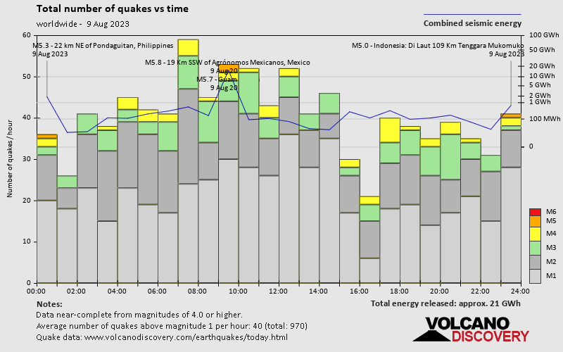
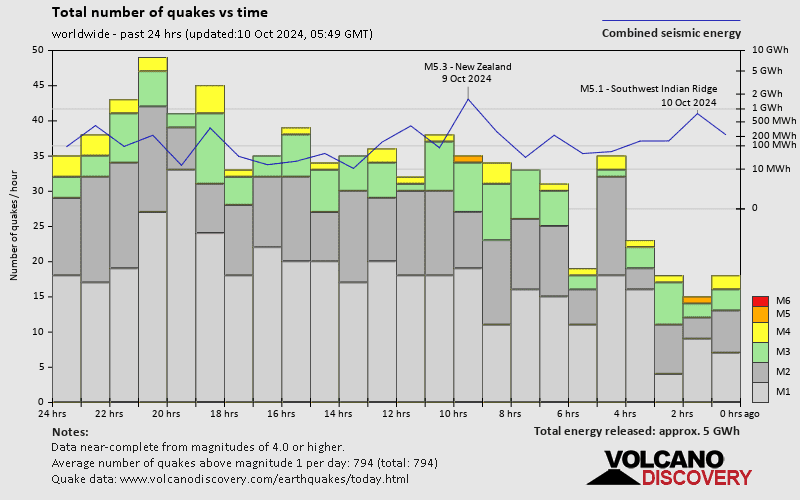
Количество землетрясений и высвобожденная энергия в зависимости от времени
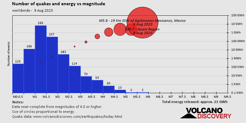
Количество землетрясений и высвобожденная энергия сверх магнитуды
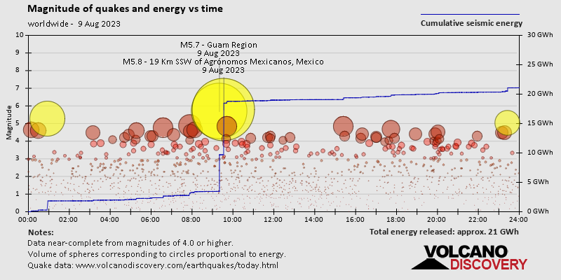
Магнитуда землетрясений и высвобожденная энергия в зависимости от времени
Updated: Aug 23, 2023 14:36 GMT
See quake list
In the past 24 hours, there were 1 quake of magnitude 6.0, 1 quake of magnitude 5.2, 29 quakes between 4.0 and 5.0, 96 quakes between 3.0 and 4.0, and 191 quakes between 2.0 and 3.0. There were also 599 quakes below magnitude 2.0 which people don’t normally feel.
A strong magnitude 6.0 earthquake occurred in Santiago del Estero, Argentina, 14 minutes ago.
Mag. 0 | 127 km NE of Santiago del Estero, Departamento de Capital, Santiago del Estero, Argentina —
Filter by magnitude:
Hide 1 unconfirmed quake
Showing quakes magnitude or higher ( out of 917 quakes, show more):
Look up past earthquakes in this area by date or date range:
Earthquake FAQ
The last earthquake in the world occurred 14 minutes ago: Strong mag. 6.0 earthquake — 127 km northeast of Santiago del Estero, Departamento de Capital, Santiago del Estero, Argentina, on Wednesday, Aug 23, 2023 at 11:22 am (GMT -3).
Where did the last earthquake happen in the world?
The last quake above magnitude 4 today occurred 14 minutes ago 127 km NE of Santiago del Estero, Departamento de Capital, Santiago del Estero, Argentina.
Smaller quakes below magnitude 4 are much more frequent and happen somewhere in the world every few minutes. However, many (if not most) of them go unrecorded, because not all areas in the world are covered by sensitive-enough seismic networks able to detect them.
Where do most earthquakes occur in the world?
In the past 24 hours, there have been 97 quakes up to magnitude 6.0.
What was the strongest quake in the world today?
The strongest earthquake in the world today occurred 14 minutes ago: Strong mag. 6.0 earthquake — 127 km northeast of Santiago del Estero, Departamento de Capital, Santiago del Estero, Argentina, on Wednesday, Aug 23, 2023 at 11:22 am (GMT -3).
What category of earthquake is considered an emergency?
Most earthquakes are small and cause no damage, but occasionally, there are bigger ones that can cause considerable damage to people and infrastructure. How much damage a quake does depends a lot on a number of factors including:
— magnitude
— depth beneath the surface
— duration and motion of the shaking
— local geology
— population density
— overall building standards of the affected area
— risk awareness and preparedness
Quakes below magnitude 5 rarely cause damage, while quakes above around magnitude 7 almost always result in extensive damage, even in areas with very good building standards such as in the western US or Japan. Quakes from magnitudes 8 often result in wide-spread or even catastrophic destruction.
What kind of damage can an earthquake do?
The ground shaking of earthquakes can cause soil liquefaction, landslides and avalanches, the opening of fissures in the ground, deformation of the ground, cracks in walls and other structures leading to their collapse. As secondary and often even more severe damage, this can lead to fires, gas leaks, or even tsunamis if the sea floor is moved in a way to displace a large mass of water.
How dangerous are earthquakes?
Earthquakes are among the (if not THE) most dangerous type of natural disaster.
According to data from the World Health Organization (WHO), quakes caused nearly 750,000 deaths globally in the period 1998-2017, more than half of all deaths related to natural disasters.
How many people are affected by earthquakes every year?
Each day, many thousands of people feel an earthquake somewhere. Stronger quakes can be felt by millions of people.
According to data from the World Health Organization (WHO), nearly 750,000 people were killed by quakes and more than 125 million people injured, made homeless or displaced or otherwise seriously affected by earthquakes during the 20 years from 1998-2017.
Try our free app!
Earthquake statistics
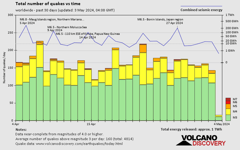
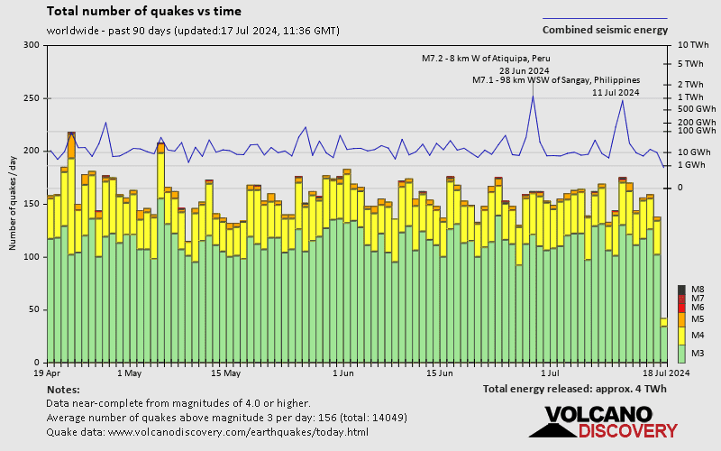
Number of earthquakes over time:
Past 24 hrs:
Past 30 days:
Past 90 days:
Credit: Earth and Planetary Science Letters, Vol 536, Zhang et al. 2020, „Prompt elasto-gravity signals (PEGS) and their potential use in modern seismology», https://www.sciencedirect.com/journal/earth-and-planetary-science-letters, with permission from Elsevier
Lightning — one, two, three — and thunder. For centuries, people have estimated the distance of a thunderstorm from the time between lightning and thunder. The greater the time gap between the two signals, the further away the observer is from the location of the lightning. This is because lightning propagates at the speed of light with almost no time delay, while thunder propagates at the much slower speed of sound of around 340 metres per second.
Earthquakes also send out signals that propagate at the speed of light (300,000 kilometers per second) and can be recorded long before the relatively slow seismic waves (about 8 kilometers per second). However, the signals that travel at the speed of light are not lightning bolts, but sudden changes in gravity caused by a shift in the earth’s internal mass. Only recently, these so-called PEGS signals (PEGS = Prompt elasto-gravity signals) were detected by seismic measurements. With the help of these signals, it might be possible to detect an earthquake very early before the arrival of the destructive earthquake or tsunami waves.
However, the gravitational effect of this phenomenon is very small. It amounts to less than one billionth of the earth’s gravity. Therefore, PEGS signals could only be recorded for the strongest earthquakes. In addition, the process of their generation is complex: they are not only generated directly at the source of the earthquake, but also continuously as the earthquake waves propagate through the earth’s interior.
An earthquake shifts the rock slabs in the earth’s interior abruptly, and thus changes the mass distribution in the earth. In strong earthquakes, this displacement can amount to several meters. » Since the gravity that can be measured locally depends on the mass distribution in the vicinity of the measuring point, every earthquake generates a small but immediate change in gravity,» says Rongjiang Wang, scientific coordinator of the new study.
However, every earthquake also generates waves in the earth itself, which in turn change the density of the rocks and thus the gravitation a little bit for a short time — the earth’s gravity oscillates to some extent in sync with the earthquake. Furthermore, this oscillating gravity produces a short-term force effect on the rock, which in turn triggers secondary seismic waves. Some of these gravitationally triggered secondary seismic waves can be observed even before the arrival of the primary seismic waves.
«We faced the problem of integrating these multiple interactions to make more accurate estimates and predictions about the strength of the signals,» says Torsten Dahm, head of the section Physics of Earthquakes and Volcanoes at GFZ. » Rongjiang Wang had the ingenious idea of adapting an algorithm we had developed earlier to the PEGS problem — and succeeded.»
«We first applied our new algorithm to the Tohoku quake off Japan in 2011, which was also the cause of the Fukushima tsunami,» says Sebastian Heimann, program developer and data analyst at GFZ. » There, measurements on the strength of the PEGS signal were already available. The consistency was perfect. This gave us certainty for the prediction of other earthquakes and the potential of the signals for new applications.»
In the future, by evaluating the changes in gravity many hundreds of kilometres away from the epicentre of an earthquake off the coast, this method could be used to determine, even during the earthquake itself, whether a strong earthquake is involved that could trigger a tsunami, according to the researchers. » However, there is still a long way to go,» says Rongjiang Wang. » Today’s measuring instruments are not yet sensitive enough, and the environmentally induced interference signals are too great for the PEGS signals to be directly integrated into a functioning tsunami early warning system.»
Journal
Disclaimer: AAAS and EurekAlert! are not responsible for the accuracy of news releases posted to EurekAlert! by contributing institutions or for the use of any information through the EurekAlert system.
Credit: GFZ Task Force
The German Research Center for Geosciences (GFZ) has set up a task force and sent a team to La Palma to contribute to the rapid assessment of volcanic eruptions and earthquakes on the islands. Together with experts in Potsdam and Spain, the researchers are investigating the interaction of the eruption with the quakes and surface deformations. They are using on-site measuring instruments and satellite images as well as data and software from the worldwide earthquake measuring network GEOFON.
After fifty years of dormancy and a three-year seismically active phase, a new volcanic eruption began on September 13, 2021, at Cumbre Vieja on the island of La Palma. Using satellite radar, GFZ researchers detected large-scale deformations indicating a pressure increase beneath the surface. The starting point of the eruption was on the central western flank of the Cumbre Vieja volcanic ridge, just a short distance north of the 1949 eruption. The lava flow is now 6300 meters long, in places over 1000 meters wide and at some places up to over 25 meters thick. It has destroyed over 600 houses and numerous roads. The lava reached the coast on September 28, 2021.
GFZ volcano researcher Thomas Walter says: «From what we hear from our team there, the situation there is still tense. Not only do enormous ash clouds form at the eruption crater, the contact of the lava, which has a temperature of over 1000 degrees Celsius, with the seawater causes the water to evaporate and also the salt molecules it contains. These react to form gases, some of which are toxic and corrosive.» He therefore strongly warns against going near the lava stream without protective equipment. One must reckon with other dangers, such as sudden explosions of vapor gases or fine ash and glass particles that are carried over many kilometers by the strong wind. The newly forming delta in the sea grows visibly, but can give way and break off again unexpectedly.
The earthquakes shift with increasing magnitudes back to the south, to the center of the Cumbre Vieja. The complex events are not easy to decipher. Therefore, the GFZ has assembled a team of experts to assess the situation using both remote sensing data and computer analysis, as well as data collected in the field. Nicole Richter, Alina Shevchenko and Carla Valenzuela Malebran, scientists in the GFZ-section Physics of Earthquakes and Volcanoes and members of the task force, had left just a few days after the eruption began, numerous scientific instruments such as seismometers, inclinometers, drones and thermal cameras in their luggage.
The first results are promising. They show an accumulation of the earthquakes at a depth of about 12 km, far away from the eruption source. Do they indicate a magma chamber? How are the eruptions related to the earthquakes and surface deformation? These are the questions that the GFZ’s geophysicists and volcanologists are investigating together with their Spanish and German colleagues. Thomas Walter: «It is still too early to say whether and how this eruption will develop, whether there will be further eruption centers — as it was usual with past eruptions on La Palma — or whether the volcano will soon lay itself to rest again. The great success of the science and local authorities is already that, despite the relatively large eruption and destruction, there was no property damage.»
The Canary Islands were formed by volcanism and still showed morphological and structural changes in their recent geological past, such as large explosions, slides of entire island flanks, or calderas. Seven of the eight islands (all except La Gomera) can be considered volcanically active. The islands are true giants: Between one million and twenty million years old, they rise up to 3715 meters above the sea. By far the greater part, however, lies under water and locally even pushes in the ocean crust. Thus, the volcanoes of the Canary Islands often have a diameter of more than a hundred kilometers. Like the tip of an iceberg, La Palma also rises out of the sea.
GEOFON (GEOFOrschungsNetz) is the global seismological broad-band network operated by the German GeoForschungsZentrum (GFZ).
Aktuelle Erdbebeninformationen
(Map:
GEOFON/GFZ)
GEOFON (GEOFOrschungsNetz) is the global seismological broad-band network operated by the German GeoForschungsZentrum (GFZ). The GEOFON seismic network came into being in 1993 as one of the three pillars of the GEOFON program dedicated to Ernst von Rebeur-Paschwitz, proposer of a global earthquake monitoring system, who recorded the first teleseismic seismogram in Potsdam in 1889.
The program and its seismic network were created to provide high quality broad-band data for scientific use and foster common standards in the seismological community. The network has evolved towards real-time data acquisition and distribution while keeping the high quality broad-band data in focus. Today the network plays a leading role in global real-time seismology providing valuable data for almost all fundamental and applied global/regional seismological research projects at GFZ and the wider seismological community.
The GEOFON network is operated jointly with more than 50 international partners and in 2014 consists of about 80 active stations on all continents, but concentrated in Europe and the Mediterranean region as well as in the Indian Ocean. Station operation is mostly performed by local partners with GFZ guidance and logistic support, allowing the global network to be well-advanced technically while still extremely cost-effective. All stations are equipped with broad-band sensors (generally STS-2) that allow resolution of the complete seismic spectrum from small high-frequency local earthquakes to the largest global earthquakes. Data from all stations are freely redistributed in real-time for earthquake monitoring and tsunami warning centers immediately after acquisition at the GEOFON data centre via wired or satellite links. Archived data is also available. G EOFON is part of the Modular Earth Science Infrastructure (MESI) housed at GFZ.
Current earthquake information here